Info:
Title: Novissima Urbis Romae Accuratissima Descriotio MV - Code: 00068Contest: Rome / 2010
By: T SPOON environment architecture
Views: 3149 Likes: 0
Votes:
JUERGEN MAYER H. 0 FRANCESCO LIPARI5 FELIPE ESCUDERO7 FRANCESCO GATTI 5 MICHAEL CATON 54.4
Novissima Urbis Romae Accuratissima Descriotio MV


The imagine of the city
The history of the iconography of Rome is very rich of drawings, stamps, incisions and paintings: for centuries Italian and foreign artists, attracted by the fashion of the Eternal City, have tried to capture an instantaneous image of its nature and to bring out the character of the more representative places of the city, usually favouring the spectacular aspect throughout great panoramas or throughout views of particular areas or monuments. Every map, besides the beauty of the drawing, constitutes a visual document of extraordinary importance, capable of giving back information on the history of the city, on the image that wanted to be perpetrated, on human activities and on the political, military and economic strategies that have guided it’s development. Cartography, in fact, has been during the centuries an instrument of knowledge and above all of power: the commissioners asked cosmographers and lands-surveyors to put into evidence, according to the necessities of acquaintance of the moment or the communicative impact that they wanted, only some of the territory aspects. It is in this way that we had, throughout realistic or often ideal views of the city, once the image of the city surrounded by walls, strong, protected and impregnable, once the image of the centralizing city, node of the communications ways and of all the exchanges, once of the holy city, instrument at use of the pilgrims, once of the ruins city, romantic, decadent, with nature that takes back its space.
Speaking today about the image of the city means in first place to take into account its dimension, real and perceived. The effects of the globalization economy, with the delocalization of industries and services, the increasing cost of living in city and the huge economic interests related to real estate, have brought to a considerable enhance of the daily mobility movements towards and out of the city in the past sixty years.
The centre remains without residents, in favour of consistent tourist flows, residents that necessarily have moved themselves out of the communal territory, in satellite towns that gravitate around the city, and that move daily toRomein order to work.Romecan’t be identified anymore with the physical boundaries of the city but it has extended to a bigger scale, to become a metropolitan city or even a regional city. This new territorial dimension needs a new type of representation and a different coordination of strategies and interventions.
From this point of view architecture must deny itself in order to find out the complexity of the territory on which it works, meant not anymore only as a space, but above all as complex system of social, political and economical relations. We can therefore speak about a city whose shape is not defined by political borders or from owners proprieties, but it is characterized from the natural limits that articulate the territory favouring or limiting the relations and the range of influence that the centre ofRomehas as a centralizing pole.
This is the forma urbis that we have to talk about today.
City Landscape Infrastructure
Artificial, natural, urban, rural, they are categories that blur the contours, that vanish into hybrid territories, spaces that are continuous subject of variations, alterations and metamorphoses, dynamic areas and receptive to changes. These places, considered secondary spaces if thought according to the consolidated relations of the inhabited urban areas, can instead become privileged places for the reading of the transformations in existence, and above all real laboratories for the experimentation of new inhabiting modalities, of new practices of transformation of the territory, and for the research of a different equilibrium between man and nature. In front of these genetic mutations of the city texture it is necessary to find new instruments that define systems that can’t anymore be stiff, stable and rational, but have to be able to answer to transformations that become faster and faster and unforeseeable, therefore adaptable, flexible and modifiable. The research of new modalities of planning and of the city transformations management is a process has necessarily to be multidisciplinary and at different scales: landscape, architecture, economy, art, ecology, philosophy, biology, sociology, computer science etc. must be borrowed in order to interpret, to represent and to plan the complexity of the city’s dynamics at various scales, from the whole city to the single artistic participation, in a continuous reflection on the importance of the single choice between simple elements and at the same time on the complex equilibrium between the parts in the composition of a whole picture.
Everything lays the intersection of three elements: city, landscape, infrastructure
City is meant not only as the relation between spaces, within their dimension and function, but mainly as a system of relations, activities and possibilities: a living organism, dynamic, unpredictable and full of spontaneous processes.
Landscape, that leaves it’s traditional role of decoration, ornament, of productive soil or of natural beauty, becomes the lens throughout we read, interpret and structure the contemporary city.
Infrastructure as the instant expression of urban landscape, the vital net of the city. Not anymore a hidden texture of technical and functional elements, but a new hybrid form of natural and technological public space.
City is landscape, landscape is infrastructure, infrastructure is city: the circle closes up, urbanity is ready for a new level of development. Architecture becomes Environment.
Hyper-infrastructure
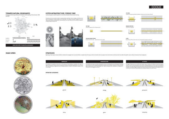
Rome, besides being beautiful, with its fashion related to history, to nature and to all the rich imagines that have been created in the course of the centuries, today is practically arrived to a collapse. Public mobility is insufficient, the road infrastructures have become swampy and uncontrolled rivers. Therefore, how can it be thought that the territorial scale can be the right dimension of action and participation? Which are the elements on which it has sense to invest? In this discouraging scene, it exists only one high capacity infrastructure of public transport that has a range sufficiently wide to structure and to support this extension of the development of the city, that is the metropolitan railroad.
Planning a sustainable urban mobility means to radically rethinking its spatial, social, economical and ecological conception, defining new strategies for the transformation of the city and for its further development.
We have to move from a purely technological and quantitative toward a qualitative point of view, based on a new relation between city and infrastructure.
In the study case ofRomethe railway infrastructure and the city have grown in different times as two overlapped but separated systems. The railway, built as a link different cities, has been wrapped by the whirling growth of the urban texture and has become today a metropolitan transportation system.
If the infrastructure crosses and strongly marks the urban texture from the suburbs to the centre, the city turns its back to the rail tracks. This builds a strong, physical and perceptive, limit between the urban environment seen from the streets and the city seen from the train’s window. The railway space is an unexpected “back” that makes you loose your bearing, a continuous territory that flows in the interstitial spaces of the traditional city, of whom it comes to be the negative: a city within the city.
The limit between infrastructure and city is a space, a “extra-space”. It’s a territory inside the city with its own rules, directly connected to the neighborhood’s local scale, but at the same time related to a railway system that works on a metropolitan, regional and national scale.
If we look at this territory as a continuous system of spaces that can redefine the relation between infrastructure and city, it can become a basic resource for the city transformation and development.
It is a hybrid space where it’s possible to develop local resources, experimenting innovative instruments and practices, towards a new relationship between city, nature, energy, mobility and communication on all the different scales.
At this purpose, three categories of intervention have been found, morphology, infrastructure and activities, through which it is possible to transform the territories of the infrastructure into an hyper-infrastructure, a system capable of carrying a variety of services capillary info the city and to build a relationship of interdependence with the territory that it crosses. The hyper-infrastructure becomes therefore active, accessible, interconnected and recognizable, capable of a changing its own characteristics based on the necessities of the city texture and to structure itself according to new strategies and lifestyles and to perceive the territory.
Related Posts :
Comments:
Info:
Title: Novissima Urbis Romae Accuratissima Descriotio MV
Time: 16 marzo 2010
Category: Rome
Views: 3149 Likes: 0
Tags: -


