Info:
Title: Interstitial landscape as interstitial tissue - Code: 00062Contest: Rome / 2010
By: S. DUMITRASCU
Views: 5320 Likes: 3
Votes:
JUERGEN MAYER H. 0 FRANCESCO LIPARI3 FELIPE ESCUDERO3 FRANCESCO GATTI 6 MICHAEL CATON 94.2
Interstitial landscape as interstitial tissue


INTERSTITIAL LANDSCAPE AS INTERSTITIAL TISSUE
PREMISE
The contemporary condition of Rome’s urban landscape is fragmented, deteriorated, and difficult to comprehend in its totality. In contrast to the richness of Rome’s historical centre, the palimpsest of the areas outside the City Walls is harder to discern, appearing to have been erased and replaced by a new landscape with modern characteristics: agglomerations of residential construction, infrastructural networks of roads, railways and highways, as well as fragments of ancient ruins scattered across open fields or hidden inside backyards of suburban houses. However, the fluctuating urban growth and decay dynamic over the past three thousand years has unavoidably left its marks both on the urban core and the surrounding territory – Rome transformed from a mythological pastoral settlement founded ‘upon seven hills’ in the eighth century BC, to the world’s largest urban metropolis in the first century at the height of prosperity of the Roman Empire, shrinking to a third of its size during the middle ages, followed by a gradual rebuilt and transformation up to present day.
A better understanding of Rome’s contemporary landscape requires a shift in focus from the dialectic between Rome’s historical center confined by the city walls and the surrounding territory of the Roman Campagna – towards a reading of the city as a rhizomatic network of voids and interstices that construct Rome’s complex contemporary urban fabric. This implies a “dismantling of traditional boundaries between city and country, a genuine examination of what is in between and the recognition that what is empty on the map is not, in fact empty space.”[1]
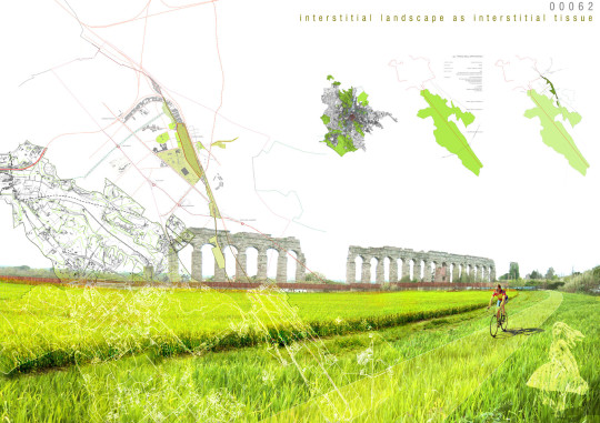
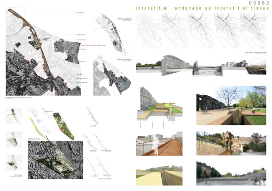
This scheme proposes re-envisioning the marginalized landscapes traversed by the aqueducts and railway lines in the south-east of Rome as an opportunity to re-establish a sense of connectivity between the city and its margins. It suggests amplifying the presence of the aqueducts in this south eastern sector of the city as a potential regenerative urban element, a historical infrastructural connection between Rome’s peripheral and central areas. The scheme seeks to create a sense of continuity between fragmented areas along the course of the aqueducts, linking the Aqueduct Park with Rome’s historical centre.
Spanning for approximately seven kilometres – from the Aqueduct Park, at the outer edges of Rome, to the Aurelian Walls at Porta Maggiore – this zone offers a unique cross sectional experience of the city, exposing a variety of conditions ranging from the openness of the Roman Campagna to the dense agglomeration of Rome’s urban periphery. This is a place of contrasts – of continuity and disjuncture of industrial and archaeological, of banal and sublime. It is both within and outside of the city, in a state of abandonment and in a constant state of flux.
This landscape is as difficult to grasp as it is to traverse, lacking legibility, territorial continuity and ease of access. It is physically fragmented and separated from the rest of the city by infrastructural arteries, property boundaries, as well as legal and illegal settlements, that impose both physical and conceptual challenges. The conflicting identity of this landscape arises from its duality as leftover, marginal space, as well as place of tremendous archaeological and historical value.
PRECEDENTS
A first response to the fragmentation and degradation of the archaeological landscape of Rome’s periphery has been acknowledged at the master planning level, by instituting legal protective measures for areas of cultural heritage as well as areas of ecological significance. Only the southern portion of the landscape traversed by the aqueducts is currently designated as protected archaeological area. The Aqueduct Park (Parco degli Acquedotti) is part of the larger regional area of the Appia Antica Park (Parco dell’Appia Antica), that was established in 1988 to prevent further sprawl and consumption of this part of the Roman territory in response to the rapid, disorganized expansion of the urban fabric. New planning strategies foresee a further extension of this protected area to create better connections with Rome’s historical centre. The landscape comprised between the aqueducts and the railway is outlined as area of environmental and archaeological significance by a series of new municipal and local plans. The Management Plan of Appia Antica Regional Park (published in 2003) proposes the enlargement of the Aqueduct Park to the north, to include the entire aqueduct system “from the current Park boundaries to Porta Maggiore”[2]. A similar proposition is sustained by the New Master Plan of Rome (Nuovo Piano Regolatore Generale – 2003) that designates a portion of the area along the aqueducts as ‘zone of environmental requalification’ (zona di riqualificazione paesaggistica ed ambientale[3]). Both of these plans promote re-establishing a territorial continuity between areas of high cultural and environmental value, as well as strengthening connections with Rome’s historical centre.
INTERVENTION
Adopting a similar methodology with that established by Rome’s New Urban Master Plan, the scheme proposes a new strategic axis of intervention to function as a connective tissue at both local and urban scales. Using the biological connotation of the interstitial (“the fine connective tissue lying between the cells of other tissue“) – the scheme focuses on the relational potential of this in-between zone, its ability to connect rather than separate places and neighbourhoods along it. This scheme examines different scales of intervention along the aqueducts through preservation/ recovery and appropriation of interstitial territories, identifying common threads, spatial continuities and temporal connections between the past, present and future of these areas.
This scheme further proposes a design intervention along a site situated between the aqueducts and via del Mandrione, a historical road running in parallel to the railway lines. Although this site is currently enclosed and separated from its context by property boundaries, the scheme proposes reconfiguring this site as a threshold between the city and its margins.
Info:
Title: Interstitial landscape as interstitial tissue
Time: 16 marzo 2010
Category: Rome
Views: 5320 Likes: 3
Tags: -


