Info:
Title: (Re)Visioning/ (Re) Imagining St. Johns Square Past - Code: Y7C4A9Contest: NY / 2012
By: D. George
Views: 3397 Likes: 0
Votes:
JOSHUA PRINCE-RAMUS2 EVA FRANCH I GILABERT2 ROLAND SNOOKS1 SHOHEI SHIGEMATSU0 ALESSANDRO ORSINI2 MITCHELL JOACHIM21.5
(Re)Visioning/ (Re) Imagining St. Johns Square Past

 (Re)Visioning/ (Re) Imagining St. Johns Square Past – The History St. John’s Park is a square in TriBeCa neighborhood of lower Manhattan, New York City. It is bounded by Laight, Varick, Beach and Hudson Streets. The square has been used for many different purposes since the colonization of New Amsterdam in the early 17th century. The land in the area was owned by Trinity Church. In 1803, the church constructed St John’s Chapel and staked out the park, which was also called Hudson Square, inspired by the private gated Gramercy Park. They intended to offer 99 year leases on plots around the square, but at that time the area was too far north of the city, so it was slow to develop. By the 1820s, the city’s expansion north had made Hudson Square a desirable place to live, and Trinity decided to sell rather than lease the lots. In 1827 the church granted use of the square to the 64 landowners around the perimeter, and St John’s Park became an upscale neighborhood. As the city grew, the expanding warehouse district began to encroach on the neighborhood, and its seclusion was shattered in 1851 when the Hudson River Railroad ran tracks along Hudson Street. Rich homeowners moved elsewhere, and St John’s Chapel went into financial difficulty. In 1866, Trinity parish sold the park to Commodore Cornelius Vanderbilt, who built a freight terminal on the site for the Hudson River Railroad.The freight terminal was removed in 1927 to make room for the eastbound exits of the Holland Tunnel. Five exits form a circular road (rotary) contained within the square and the inner portion of the square inaccessible to pedestrians.
Present – The Problem
St. Johns Park is a small circular inaccessible green park with the Holland Tunnel traffic swirling around it. It is an area downtown notorious to noise and air pollution, unsafe to pedestrians. Manufacturing of the past has moved on and buildings’ surrounding the square over time have all been converted to residential lofts and apartments and is now an established historic New York neighborhood polluted by traffic from the Holland tunnel and lacking a central green space.
Future – The Proposal
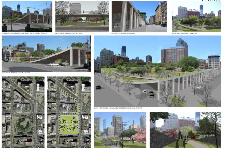
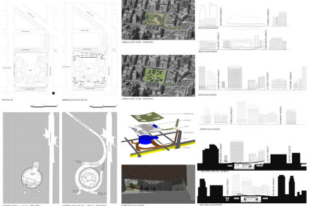
St. Johns Park proposal is a 4 acre urban scale superblock promenade, green and art focused space which provides Tribeca and the surrounding neighborhoods with a new dynamic landscaped terrain and a new means for pedestrians to safely connect across neighborhoods and for cars from the Holland tunnel to transition to the city streets in an efficient way allowing other uses to coexist on the site. It features three ordering mechanisms to resolve the current traffic, noise, air pollution and importantly the physical barrier and safety issues limiting pedestrian’s access and occupation.
-
The first concept is the Holland tunnel exit roadway and rotary is buried below grade. Exits from the rotary below grade are via ramping up to the city streets in the current exiting locations at the four corners of the square. This frees the ground-scrape claiming it for a green space and planted sidewalks for ease of pedestrians use. Vestry Street is reopened to both pedestrian and traffic flow directly west into Canal Street or is free to loop around into Laight Street. Ericsson Street is established as a local street again without the traffic bottle neck, with municipal parking along the parks side as the Holland exits separately from its lanes directly onto Varick Street.
-
The second feature is ‘the green roof square’, a gentle curving topography, set on a structured threshold, elevated at north and south edge at Laight and Ericsson Streets respectively, as a place for relaxing, fitness, picnicking, concerts, film festivals, people watching and looking back at the city at the planted elevated overlook paths along the edges. Pedestrian access to the park is through gateway underpasses at the four corners of the square, along the east-west axis facing Varick and Hudson Streets and at the mid-south edge along Ericsson Street. Existing trees are relocated and new are planted in a new layout around the square pathways. Water runoffs is collected in tanks below the structure and used for watering the plants.
-
The third feature is the introduction of commercial activity along the north edge at Laight Street to draw pedestrians to retail shops and restaurants adjacent to Canal Street, providing a sustainable means to maintain the park. Guest accommodations and maintenance facilities are tucked under the structure on the south edge at Ericsson Street.
This proposal (re)imagines St. Johns Park, linking its new function and context to its historical past and claiming its rightful place as a significant open space in the fabric of the New York City.
Info:
Title: (Re)Visioning/ (Re) Imagining St. Johns Square Past
Time: 13 giugno 2012
Category: NY
Views: 3397 Likes: 0
Tags: -


